The burden of pollution on Chicago communities
Calculating a relative pollution burden Heading link
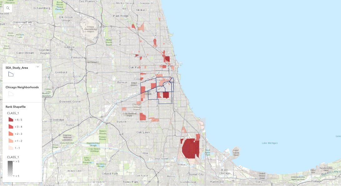
In order to study the relative pollution burden within the Southwest Environmental Alliance (SEA) study area, a relative pollution burden (RPB) metric was created for each block group. This metric includes all of the Toxics Release Inventory facilities emissions along with the acreage of brownfields as an indicator of pollution burden for local communities. Each variable was standardized (zero to 100 scale) and added to yield the RPB. The relative pollution burden index (RPBI) is derived by multiplying the RPB by the standardized sensitive population number for each block group. For this specific application, the number of children less than 10 years old were used. The distribution of this index is shown in the map above with five levels (classes) of burden. The SEA area is highly ranked in terms of relative burden and its populated areas are surrounded by block groups with a high levels of pollution burden.
Able Electronics Co. Inc. reported emissions (North Lawndale) Heading link
| Chemical | Total air lbs. |
|---|---|
| Lead | Not applicable |
| Nickel | Not applicable |
| Nitric acid | 660.0 |
| Chromium compounds | 5.6 |
| Manganese | Not applicable |
| Nitrate compounds | Not applicable |
| Trichloroethylene | 22,749.0 |
Aardagh Metal Beverage USA Inc. reported emissions (New City) Heading link
| Chemical | Total air lbs. |
|---|---|
| N-butyl alcohol | 37,714.0 |
| Certain glycol ethers | 90,775.0 |
| Manganese | Not applicable |
| Lead | Not applicable |
Bway Holding Co. reported emissions (Little Village) Heading link
| Chemical | Total air lbs. |
|---|---|
| Xylene | 2,002.0 |
| Toluene | 19,029.0 |
| Ethylbenzene | 9,975.0 |
| Methyl isobutylene ketone | 712.0 |
| N-butyl alcohol | 8,052.0 |
| 1,2,4-trimethylbenzene | 4,044.0 |
| Certain glycol ethers | 40,622.0 |
Clean Harbors Recycling LLC reported emissions (New City) Heading link
| Chemical | Total air lbs. |
|---|---|
| Ethylene glycol | Not applicable |
| Methanol | 11,738.4 |
| Chlorobenzene | Not applicable |
Edsal Manufacturing Co. Inc. reported emissions (New City) Heading link
| Chemical | Total air lbs. |
|---|---|
| Chromium | 0.1 |
| Manganese | 32.8 |
| Nickel | 0.1 |
| Certain glycol ethers | 24,661.0 |
Empire Hard Chrome Inc. reported emissions (North Lawndale) Heading link
| Chemical | Total air lbs. |
|---|---|
| Lead compounds | Not applicable |
| Chromium compounds | 37.0 |
H. Kramer & Co. reported emissions (Lower West Side) Heading link
| Chemical | Total air lbs. |
|---|---|
| Manganese | 5.0 |
| Chromium | 2.0 |
| Nickel | 5.0 |
| Copper | 55.0 |
| Lead | 15.0 |
| Phosphorus | 645.0 |
| Zinc compounds | 105.0 |
The essence of the industrial burden problem Heading link
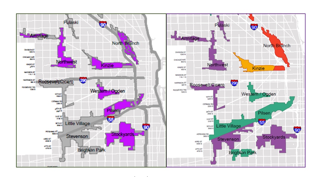
Location is a major source of the Southwest Environmental Alliance communities’ pollution burden. It is the only densely populated residential area within Chicago that is surrounded by a highway (Interstate 90) and large areas of industrial corridors (gray in the map above) and Planned Manufacturing Districts (PMD; purple in the map above). PMD areas are designated for heavy industrial uses. This explains the heavy Toxics Release Inventory facilities presence in the Pilsen and McKinnley/Bridgeport/New City (Stockyards) communities. The five largest PMDs (Stockyards, Northwest, Kinzie, Calumet, and Pilsen) contain more than 70 percent of all PMD building space in the Chicago area.
The Chicago’s Industrial Corridors Employment Trends assessed by the City defines what the city planners are thinking in terms of development. Based on their assessment, the community areas within the SEA catchment will be mainly employed in “manufacturing” (purple) and “moving & storing” (green). In comparison, the employment trend for the rezoned north branch is “information and technology” (red) and “business to business” (orange).
At the July 26, 2017, City Council meeting a new City of Chicago ordinance was approved (O2017–4840). This ordinance converts part of the Kenzie and North Branch industrial corridors to other designations (including residential). In addition, an Industrial Corridor System Fund was created “for the preservation, development and/or growth of industrial uses in receiving corridors”. Based on the ordinance document “receiving corridors means those industrial corridors in which the primary sources of jobs are in industrial use categories. As of the effective date of the ordinance, eligible receiving corridors are: Armitage, Brighton Park, Burnside, Calumet, Elston/Armstrong, Greater Southwest, Harlem, Kennedy, Kinzie, Knox, Little Village, Northwest, Northwest Highway, Peterson, Pilsen, Pulaski, Pullman, Roosevelt/Cicero, Stevenson, Stockyards, West Pullman, Western/Ogden, and Wright Business Park.”
Given the location of the SEA communities, this implies that the City will be investing in the “development and/or growth of industrial uses” in the area, and it is only a matter of time.
Essence of the burden problem, continued. Heading link
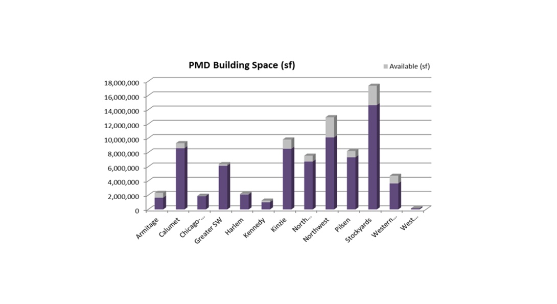
The adjacent graph, from the 2017 Industrial Corridor Modernization Initiative, underlines another dimension of the planned manufacturing districts problem for the Southwest Environmental Alliance area; namely that the Pilsen and Stockyards communities contain almost 40 percent of the entire cities planned manufacturing district building space.