Identifying environmental hazards within southwest Chicago

Introduction Heading link
The Southwest Environmental Alliance (SEA) is a coalition of groups from Pilsen, Little Village, Back of the Yards, Bridgeport, Canaryville, Brighton Park and McKinley Park formed to address the ongoing pollution and health impacts from the high density of polluting facilities within the industrial corridors encircling their neighborhoods.
These communities are largely Latino and have per capita income levels that are substantially lower than the city average. Through the conscious planning and support of the City of Chicago, the number of facilities in the surrounding industrial corridors is increasing, along with levels of pollution and health effects like increasing rates of cancer, asthma and respiratory disease. SEA is partnering with the UIC School of Public Health to further illustrate, educate and empower community members on the systemic pollution enabling the SEA communities to work with the City of Chicago to stop this environmental justice issue and improve the health of these communities.
Southwest Environmental Alliance landscape map Heading link
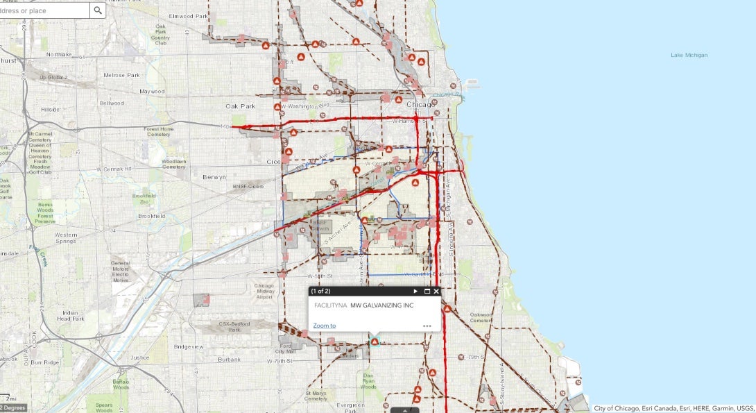
The map above, with a link to the interactive map below this text box, is an interactive web application which highlights the many point and aerial sources of pollution within the SEA study area. There are a large number of sites registered under the Toxic Release Inventory (TRI). Facilities that file under the Toxic Release (TRI) Program are large scale producers that generate hazardous releases above a certain regulatory threshold. Facilities that produce releases under the regulatory threshold do not report.
A major concern for the SEA communities are the numerous asphalt-producing facilities that are not listed in the TRI program. In addition to the many TRI facilities within the SEA area there are multiple freight hubs which are known to contribute to elevated levels of particulate matter and ozone in air (Laidlaw et al., 2012.)
Three major traffic highways are located within this area (I-290, the I-55 and the I-90). Hawthorne and Richard (2018) document that communities living adjacent to major highways have experienced elevated levels of air pollution specifically from diesel, and in some cases lead.
View the interactive map
Demographic characteristics of Southwest Environmental Alliance study area Heading link
| Zip code | Population density (square miles) | Total population | Less than 10 years old | Less than 10 years old (percentage) | More than 60 years old | More than 60 years old (percentage) | Hispanic or Latino | Hispanic or Latino (percentage) | Per capita income |
|---|---|---|---|---|---|---|---|---|---|
| 60608 | 12,568 | 79,205 | 8,358 | 10.6% | 11,411 | 14.4% | 40,146 | 50.7% | $21,477 |
| 60609 | 7,944 | 61,495 | 9,610 | 15.6% | 9,609 | 15.6% | 32,860 | 53.4% | $17,436 |
| 60623 | 16,007 | 85,979 | 14,428 | 16.8% | 11,671 | 13.6% | 56,864 | 66.1% | $13,678 |
| 60632 | 12,249 | 91,039 | 14,750 | 16.2% | 12,635 | 13.9% | 76,434 | 84.0% | $16,648 |
| Total or average | 317,718 | 47,146 | 14.8% | 45,326 | 14.3% | 206,304 | 64.9% | 17,302 | |
| Chicago metro | 11,943 | 2,718,555 | 333,581 | 12.3% | 465,426 | 17.1% | 788,140 | 29.0% | $46,573 |
Explore our data analysis Heading link

About the authors Heading link
- Michael D. Cailas, PhD, is an associate professor of environmental and occupational health sciences at the UIC School of Public Health. He directs SPH’s Public Health Geographic Information Systems online certificate program, and his research focuses on water quality monitoring network design, environmental data analysis, risk assessment and cost benefit analysis
- Peter J. Geraci is an affiliate faculty member with SPH’s division of health policy and administration.
- Joel Flax-Hatch is a research assistant and MS in Environmental and Occupational Health Sciences student at the UIC School of Public Health.
- Kristin Osiecki, PhD in Environmental and Occupational Health Sciences ’13, MS in Environmental and Occupational Health Sciences ’11, is an assistant professor at the University of Minnesota Rochester and an adjunct instructor of health policy and administration at the UIC School of Public Health.
- Apostolis Sambanis, PhD in Environmental and Occupational Health Sciences ’16, MS in Environmental and Occupational Health Sciences ’12, is the director of curriculum with SPH’s Emergency Management and Resilience Planning certificate program.
Acknowledgement Heading link
This work would not have been possible without the guidance and support of the leaders and organizers at the Southwest Environmental Alliance. We would like to give special thanks to Theresa McNamara, Mary Gonzales, and Gregory Galluzzo for their hard work and support in promoting environmental justice for communities within the Southwest Side of Chicago.
For questions regarding data acquisition and calculation please reach out to Dr. Michael Cailas.
References Heading link
- Laidlaw, M.A., Bahrain, S., Mielke, H.W., Taylor, M.P., & Filippelli, G.M. (2012) Re-suspension of lead contaminated urban soil as a dominant source of atmospheric lead in Birmingham, Chicago, Detroit and Pittsburgh, USA. Atmospheric Environment, 49, 302-310. doin: 10.1016/j.atmosenv.2011.11.030.
- Hawthrone, M., & Richards, A. (2018, September 9). EPA finds rail yards transfer pollutants as well as freight.
- Curran, T.C. (1999, February 10). Memorandum Interpretation of the Definition of Fugitive Emissions in Parts 70 and 71.
- Reiff, J.L., Keating, A.D., & Grossman, J.R. (2005). Encyclopedia of Chicago.