Climate change adaptations for healthcare
Story text Heading link

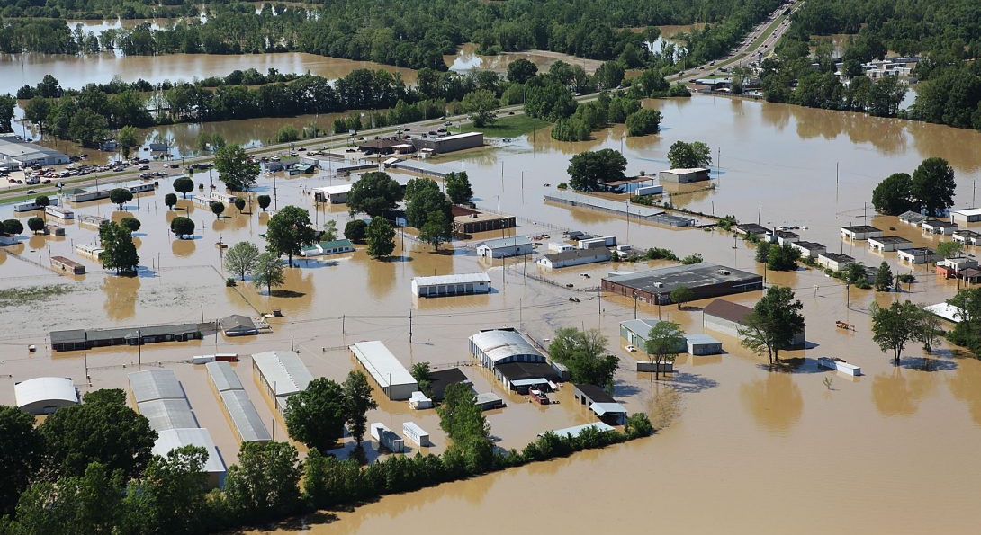
In early 2019, the contiguous United States recorded the wettest winter on record. As spring kicked into gear, a blizzard powered across the Midwest, followed immediately by rising temperatures into the 60s and heavy rain. With the ground still largely frozen across the region, rapidly melting snow and rainwater led to flooding on a massive scale, including in Illinois towns and cities.
Flooding is the leading cause of federal disaster declarations in Illinois, and climate change will exacerbate flooding in the future. At the UIC School of Public Health, a team of researchers working to prepare the state for the health effects of climate change is studying how extreme precipitation can impact healthcare facilities’ flood preparedness activities and is developing tools to inform their plans. Their results, published in the journal “Disaster Medicine and Public Health Preparedness,” identified major gaps in awareness, capacity and preparation for severe flooding.
“We’re seeing with COVID that the local level continues to be the place where responses to disasters happen,” said Elena Grossman, MPH in Community Health Sciences ’11 and program director of Building Resilience Against Climate Effects, a project funded by the Centers for Disease Control and Prevention. “As state-level programs, we have a role to play to provide these resources to local level activities.”
With the Ohio River forming a portion of the state’s southern border, the Mississippi River lining the state’s western border and its tributaries coursing through the state, numerous Illinois towns and cities are in 100 and 500-year floodplains. The challenges are not only a downstate issue; according to the Chicago Metropolitan Agency for Planning, vast sections of the south and west regions of the Chicagoland area are at heightened risk for urban flooding.
Grossman and co-author Michelle Hathaway, PhD in Environmental and Occupational Health Sciences student, built an interactive map plotting the geographic relationship of every hospital, primary care center, long-term care facility, dialysis center, ambulatory surgical treatment center, pharmacy and public health department across the state in relationship to 100 and 500-year floodplains, based on 1996 standards. They also developed a survey that was completed by administrators of healthcare facilities and public health emergency preparedness professionals to gauge their awareness of local facilities in floodplains and if an interactive map would be useful for their flood preparedness and readiness.
The survey revealed that nearly one-third of respondents who work at the state, region, county or city/town level in planning and emergency preparedness reported not knowing where floodplains are located in their respective area. About ten percent of hospital and long-term care facility respondents were unaware of whether their buildings were at risk. The map itself identifies 40 facilities across the state in floodplains. Among the 40, 12 are long-term care facilities.
The goal is for the map to be a resource in planning for healthcare facilities and encouraging action. The data is limited by the existing federal floodplain designations from 1996, as climate change continually alters flooding patterns. Regardless, Grossman says the research team’s spatial analysis builds the case for climate change adaptations and mitigations in healthcare facilities.
Adaptation activities plan for the inevitable impacts from climate change and reduce risks. One lesson drawn from Hurricane Sandy is the need to locate emergency generators in above-ground locations. Future hospital construction could locate parking areas at the ground level and commence indoor spaces on the second level. Emergency preparedness plans can move points of dispensation of water and supplies to victims in a disaster away from facilities in flood plains.
Mitigation activities seek to slow down climate change by reducing greenhouse gases. Hospitals are huge producers of carbon emissions and plastic waste. Healthcare facilities might seek to utilize sunlight as much as possible to reduce electricity usage, switch off computers and monitors when not in use, optimize energy efficient windows and green roofs (roofs with planted vegetation) to improve insulation, and replace conventional energy with renewable energy sources such as solar, wind or geothermal.
The U.S. Federal Emergency Management Agency is working to update Illinois’ floodplain designations, which will offer stronger geographic data for planning and preparedness. Grossman says the definition of healthcare facilities should be expanded as well. For example, this study did not include methadone clinics, a connection point to vulnerable populations that would be impacted by a flooding disaster.
“We’re hoping to assess whether healthcare facilities utilized the map to inform and update their hazards assessment and flood preparedness plans,” Grossman said. “Considering that increased frequency and severity of flooding is the biggest climate change concern for Illinois, we are hoping to assess the relationship of other health-related infrastructure to floodplains.”
Other contributors to the study include the UIC School of Public Health’s Apostolis Sambanis, PhD ’16, MS ’12 and director of curriculum with SPH’s Emergency Management and Resilience Planning certificate program and Sam Dorevitch, MD, associate professor of environmental and occupational health sciences. Amber Khan, a PhD student at the University of Washington, is also a co-author.